
An adventurer’s guide to New Zealand
With everything from golden surf beaches to whitewater rivers, alpine huts to need-to-be-kayaked lakes, New Zealand is a country packed with adventures at every turn of the road. Mary Creighton and her trusty 1996 Subaru tracked down the South Island’s best offerings
Ask anyone you know for their list of places they want to visit. I bet you my plane ticket home that New Zealand (NZ) is in their top five (unless they’ve already visited it, in which case they’re desperate to go back).
From Lord of the Rings enthusiasts to wannabe photographers, it has got mass appeal. But it’s the adventure seekers who will feel the biggest pull: Himalayan-esque mountains offering full-on hut-to-hut expeditions; raucous cascades asking to be canyoned; ever-changing glaciers with 100-year-old ice; lakes, rivers and fiords that need to be paddled and sprawling national parks made for exploring: NZ has it all.
In summer 2014, my husband and I moved to South Island. The plan? To do a four-month ski season and a whistle-stop tour of the country before heading back to reality. 11 months later we were still there, tracking down adventures in our clapped-out Subaru.
The truth is, a few weeks isn’t enough to explore a country that changes landscape with every turn of the road; one that falls from alpine terrain to rainforest to driftwood-strewn beaches in a matter of miles. But, for those of you who only have a couple of weeks to spare, we’ve whittled down the best stops.
Just pack a tent, a map, some insect repellent and go.
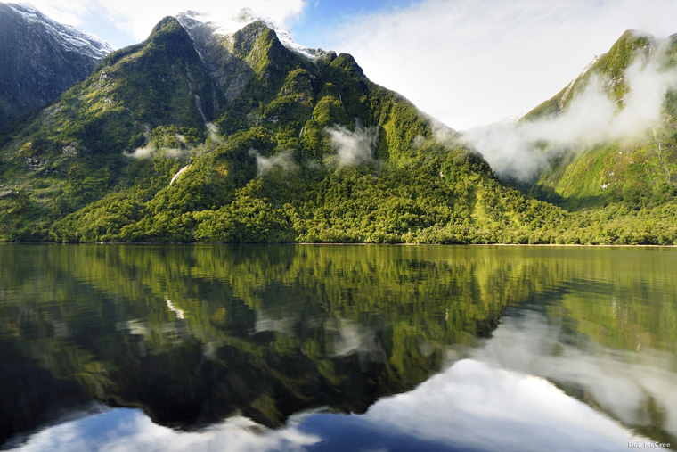
New Zealand’s fiordland: perfect for exploring by kayak |Photo Bob McCree / Tourism New Zealand
DAY 1: ARRIVE IN CHRISTCHURCH
Check into a motel. Shower. Sleep.
DAY 2: DRIVE TO AKAROA
The drive from Christchurch to Akaroa give the first hint of NZ’s ever-changing landscape. Within half an hour you’ll have driven from city to wide plains, around grass-covered volcano craters to the Pacific sea. The village itself looks like some peculiar hybrid of Devon, the Côte d’Azur coast and the Peak District; the rolling green hills could be straight out of Derbyshire, the sea is almost Mediterranean and, if you close your eyes, that smell of fish and chips transports you straight to Salcombe. To add to that funky mix, the street and business names are en Francais, Akaroa being NZ’s only French settlement.
Situated on the Banks Peninsula, the village’s harbour is actually an old volcano crater, and is a great spot for sailing (www.sailingakaroa.co.nz). As you hail the force of the pacific winds, head to Flea Bay, which boast NZ’s largest little penguin colony, and keep an eagle eye out for Hector’s dolphins, a species unique to New Zealand.
DAY 3: DRIVE TO LAKE TEKAPO
From the east coast drive straight towards the mountains, and watch as the Southern Alps sneak into the horizon. Expanding 450km along the island’s spine, and home to the country’s tallest peaks and some 3000 glaciers, they are hard to miss, and the geographical wonders that spawn off them define the country.
Lake Tekapo is just one these wonders: an icy blue lake backing straight into Mount (Mt)Cook’s foot hills. The lake itself, made a distinct colour blue by the glacial rock flour that’s pulled from the mountains (neighbouring lakes Ohau and Pukaki have the same effect), is calling to be swam or kayaked, but the real highlight is the night’s sky. The 1700 square miles that surround Tekapo is designated a ‘Dark Sky Reserve’. Free of light pollution, its startlingly clear sky is a haven for stargazers.
An hour’s hike from the north of the lake is Mount John University Observatory, the world’s southernmost of its kind. Earthandskynz.com run night-time observatory tours, complete with access to powerful telescopes. Or you can just find a bench, lie back and drink in the stars.
DAY 4: MT COOK
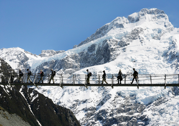
New Zealand’s highest peak, Mount Cook, is surrounded by classic hiking routes. |Tourism New Zealand
Just an hour’s drive and you’re right into the heart of the mountains, with the icy tops of NZ’s highest peaks descending straight into the grey, gravelly moraine below. There’s a myriad of hiking options from Mt Cook Village, from half-day tramps to full-on mountain expeditions. But we’re on a schedule so there’s only time for two of them.
First up: Sealy Tarns, a two-hour hike with 2200 steep steps, tests your mettle, but every rasping breath leads you closer to a worthwhile vista; Mt Sefton, draped in glaciers directly in front of you, and to your right the south face of NZ’s tallest mountain, Mt Cook (3724m) looms over you. Plus,if you need to cool off, the tarn at the top of the walk is ideal for a wild swim.
Head back down, recover and grab lunch. Then try the three-hour Hooker Valley track, which follows river beds and crosses swingbridges for 90 minutes. The reward? A glacial lake in the shadow of Mt Cook, complete with icebergs and heart-in-your-mouth views.
DAY 4-6: MT COOK – THE CATLINS
Road trip time. The five-hour drive to the Catlins, in the south-east of the island, is eye candy. Take your time driving past alpine lakes, over rolling hills, through plains and coastal splendour. Stop off at Oamaru, a Victorian town with a Steampunk Museum, the unnaturally spherical Moeraki boulders, and Dunedin (home to the world’s steepest hill), before heading into the Catlins.
Situated on The Southern Scenic Route, it’s an almost deserted area made up for rainforest, farmland and sweeping beaches. The network of coves, sandy beaches, wave-eroded rocks and blowholes are testament to the five-metre swells that batter this corner of New Zealand. Of course, it also means it’s got good surf spots (Porpoise Bay and Curio Bay) and some out of-this-world coastal tacks (Cathedral Coves and Jack’s Blowhole). Department of Conservation (DOC) camping spots at Papatowai and Purakaunui Bay make ideal overnight spots, seconds from the coast.
DAY 6-9: STEWART ISLAND
Stewart Island is 85% National Park, so best explored on foot. |Photo John Papic
Carry on down the Scenic Route, through Invercargill to Bluff. From there an hour-long ferry takes you to Stewart Island, the country’s third largest inhabited island. I say inhabited, just 400 people live here – nearly all of them in the town of Oban, with 85% of the island being part of the Rakiura National Park.
The 20km of road only covers a tiny section of the island, so the best way to get a taste of this untouched part of the world is to hike it, with one of New Zealand’s nine Great Walks (see above), the Rakiura Track giving you a three-day taste. Covering 39kms, it loops round from Oban and deep into the national park, across golden beaches, mudflats and inlets, through dense rainforest and over hills.
Two overnight huts break up the journey and both make excellent spots for late-night kiwi-hunting.
DAY 9-11: TE ANAU AND FIORDLAND
From one great adventure to the next. A two-hour drive from Bluff takes you to Te Anau, gateway to Fiordand National Park. Stretching across 12,500km, it’s named for the 15 fiords (the NZ spelling of fjord) – flooded glacial valleys with steep sides that jut straight out of the oily waters below. Milford Sound is easily the most famous, with one million tourists visiting a year. Doubtful Sound, its larger, deeper and more tranquil neighbour, is just as worthy of a visit
Our tip: do it by kayak (realjourneys.co.nz). After a cruise across Lake Manapouri (20 minutes south of Te Anau), and a 45-minute bus journey over the Southern Alps, you’ll arrive at Deep Cove. From there you can explore the dark water and get up close to the waterfalls that cascade straight from the tree-covered sides to the fiord below. Camping overnight on the side of Hall Arm is a true ‘get away from it all’ experience.
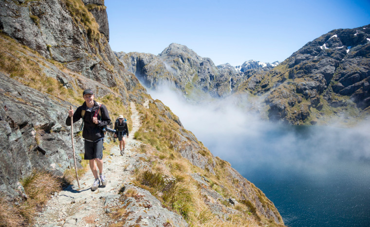
The Routeburn track is a 32km alpine track – but the views are well worth the effort. |Photo Vaughan Brookfield/ Tourism New Zealand
DAY 12: GLENORCHY
You could stop off in Queenstown on your way, but although NZ’s self-proclaimed ‘Adventure Capital’ does boast Lake Wakitipu and The Remarkables as its backdrop, the town is teeming with tourists and pricey activities.
Stop for an ice cream, if you must, but then carry on through to the head of the lake, past the Lord of the Rings-like scenery of Glenorchy, to the start of the Routeburn track. It’s another of New Zealand’s great walks, a hardy climb across the Southern Alps that lasts three days.
If you have the time – and the stamina – do all 32km of it. But, if time is tight, a day walk to the Routeburn Falls gives you a taste of what the fuss is about. The track meanders past gorges and up steep mountain paths to the streams that cascade down the mountain.
The views are extraordinary; glacier-carved valleys and snow-drizzled peaks.
DAY 13: WANAKA
While Queenstown is plagued with tourists, Wanaka, an hour north, walks the line of adventure hub and soon-to-be-discovered-backwater nicely.
Name an activity – you can do it here: horse-riding in the Cardrona valley, canyoning deep in the Haast Pass, kayaking in the lake, skydiving over the Southern Alps, it has it all.
Yes, it gets busy in the peak season, but its situation is breathtaking, overlooking Lake Wanaka and guarded by the peaks of Mt Aspiring National Park. Again, you’re spoilt for day hikes, but one that is not to be missed is the Rob Roy Glacier Track.
Drive into the national park (prepare for some seriously dangerous visual distractions as you drive around the lake, followed by some hair-raising stream crossings) and pull up on the Raspberry Flat car park.
A three-hour uphill tramp brings you face to face with the Rob Roy glacier. The terminus hangs above the valley, and you can watch waterfalls and avalanches and ice chunks roll down the mountain front of you.
DAY 14-15: THE WEST COAST

The wild rivers of the West Coast are ideal whitewater rafting spots | Photo Ian Trafford / TNZ
Back in the car, travel sickness pills at the ready. You’re about to cross the Haast Pass, one of the most hair-raising roads in the developed world, subject to week-long closures due to landslides (when we drove through the cars were ushered through one at a time as roadworkers checked the cliffs for signs of movement above).
It’s a stunner though, crossing the continental divide from arid mountains to the rainforests of the west coast. Towns are far and few between here, but Kodak moments can be found with every bend of the road.
A must-do is an overnight hike of the Copland Track. The 18km track leads through dense rainforest and rocky river beds to the Welcome Flat hut and campsite.
The real treat here are the natural hot pools, just two minutes from the hut and extremely welcome after a day’s tramp.
After hiking back to the car the next day, drive to driftwood-strewn Gillespie’s beach near Fox Glacier, set up camp and watch the sunset. Magical.
DAY 16: GLACIER COUNTRY
The West Coast road takes you almost straight past two of New Zealand’s best-known glaciers: Fox and Franz Josef. They are geological anomalies, starting high in the southern alps and descending into rainforest just a few kilometres from the sea.
There’s only one other glacier like them in the world, Argentina’s Perito Merino glacier.
Alas, it has been a bad few years for the glaciers, with rapid retreat leaving them icy shadows of their former self. From the bottom, they’re a bit of a disappointment: dirty ice cubes that descend into gravelly moraine. But from the top they are majestic alpine angels glowing in white. So, if you are interested, it’s well worth splashing out on a heli-hike (franzjosefglacier.com) to see them in all their glory. From there, drive over Arthur’s Pass and head back to Christchurch. Or burn your passport and carry on exploring…